Fort Mountain Hiking


Fort Mountain State Park is a hidden jewel when it comes to hiking trails. The state park is within 5 miles to the Cohutta Wilderness as the crow flies. But unlike the trails in the Cohutta Wilderness, the trails in the park may be reached via a paved road.
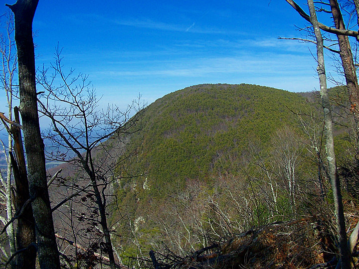
Looking at Fort Mountain from a distance you will see a northern peak which is Fort Mountain and 5 miles to the south a southern peak which is Cohutta Mountain. Shaped like a barbell with weights. A ridgeline connects the two peaks and approximately halfway between the two peaks there is Fort Mountain Lake which is a popular summer attraction.
At the northern end and high peak is the old firetower along with the remnants of an old wall that was built before the Cherokee Indians settled here and is a mystery to its orgins. A short distance from the fire tower there is a lookout porch giving a magnificient view of Chatsworth, GA and the surrounding valley. At the other end of the ridgeline there is a radio tower and old radio station building that is no longer in use at the southern peak.
A day visit to the State Park cost $5.00. A great value considering the ease of transportation to the trailhead. Or you can purchase an Annual Parking Pass for $50. There is a summer beach on the lake for families with kids along with a playground and minature golf. Also numerous cabins are available for rent along with a RV campground and even 4 permited campsites in the forest on the Gahuti Trail for $10 an individual per evening. The official website link for further info Fort Mountain State Park.
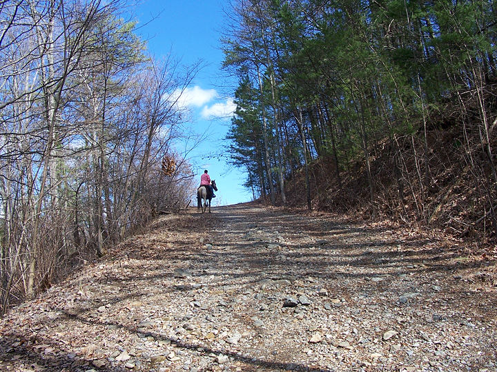
You may want to sign in at the front office if you plan to hike any mountain bike or horse trails. In case, they need to find you. The mountain bike trails are 301,302, and 303. The horse trails are the 400s trails. These trails are the hidden jewels of this trail system. Nobody hikes them because nobody knows them.
I have been hiking these trails off and on for a decade-plus and have only encountered another hiker once, twice horseback riders, and once mountain bike riders. Incredible since the trails although may be rocky are wide and I rarely worry about stepping on a snake, unlike the Cohutta Wilderness.
Some of these trails pass right by abandon mines from over a century ago and the rock formations are unmatched for the area. Beautiful formations and extensive in many areas. Hikers once aware of these trails will love them.


Fort Mountain is known for its Black Bear population. Some people say it is the highest density of black bears in Georgia. The density of food that they thrive on is high in this area. I have seen 3 times as many bears here compared to the Cohutta Wilderness. In fact, my fear of them disappeared here because I ran into them so often.
However, this is the only place I hike that I carry 100% of the time Bear Spray. I hike alone a lot and just as insurance for a house it only takes one that is an anomaly. Yet, I have zero fear while I am hiking and enjoy the sightings when they happen. Or until I'm attacked.
The Gahuti Trail is the crown jewel of the trail system and is very popular among hikers and the common folk. This is the only trail that would be surprising if you saw no one, especially on a pretty fall or spring day. The Gahuti Trail travels around the edge of the park, passing just below the summits of both Cohutta and Fort Mountain.
On a pretty spring or fall day, there is no better trail in the area. Even during the summer the trail is wide and well-maintained. It offers views of Big Frog Mountain on the eastern section of the trail during cooler parts of the year and beautiful views of Chatsworth-GA, and the valley while hiking the western section year-round.
The 301 Trail hiked end to end is probably one of the most physically challenging trails in the area. I have never hiked it end to end preferring to concentrate just on the loop section of the trail which provides unmatched diversity in what you will see. From a beautiful ravine hike to passing mines, a campground that used to be a helicopter pad in the 70s for tourists, and some of the prettiest rock formations in the South.
There is no other trail in the area that allows you to experience so many different environments. Users travel from mountain ridge top to valley floor, through pine and scrub laurel thickets, upland hardwood and cove forests, by old mines, then waterfalls and rhododendrons along Hassler’s Mill Creek before returning up the mountain.
The 401 Trail is unique in that you will not start at its trailhead unless you start from Fort Mountain Horse Campground. It is the furthest trail from the ridgeline and is an essential trail of many interior loop trails. It is one of the most solitude trails I have ever hiked with a wide path and the feeling that I am the only one who has ever hiked the trail.
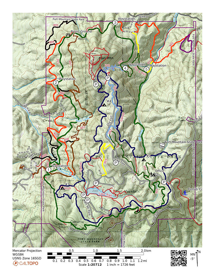
| Trail Colors | |||
|---|---|---|---|
| Gahuti Trail: | Navy | ||
| 301 Trail: | Green | ||
| 401 Trail: | Orange | ||
| 407 Trail: | Brown | ||
| 302 Trail: | Baby Blue | ||
| 303/410 Trail: | Yellow | ||
| 400/403/404/405/408 Trail: | Black | ||
| 412 Trail: | Purple |
There is no other trail like the 407 Trail in North Georgia. There is nothing like it in the Cohutta Wilderness, Big Frog Wilderness, or the surrounding trails in the Chattahoochee National Forest. This 4 mile trail traces its path below the largest rock formations in the area starting approximately 4/5 up the mountain and tracing its way on the contour north to south or south to north depending on which way you are hiking. If you travel to Fort Mountain from Chatsworth,GA the rock formations near the top of the northern summit is where the trail traces right below continuing along the contour and passing abandon mines and a waterfall in its southern section.
| Fort Mountain State Park | |
|---|---|
| Gahuti Trail: | 8.2 miles |
| 301 Trail: | 14.6 m |
| 302/301/401 East Loop Trail: | 5.2 m |
| 302/301/401 West Loop Trail: | 7.8 m |
| 301/401/407 Loop Trail: | 11.0 m |
| Pinhoti Trail: | 10.0 m |

You may sign in with the front office to hike any mountain bike trail which are trails 301,302, and 303. Or any horseback riding trails which are represented by the 400s. There is a $5 daily fee to park your vehicle or you may purchase an annual pass for $50.
Trail rules demand right-of-way for any mountain bike rider or horse back rider. Hikers who encounter one or the other stand aside for everybody's safety.